FlightScan
Drone Mapping and Modeling For Construction Projects
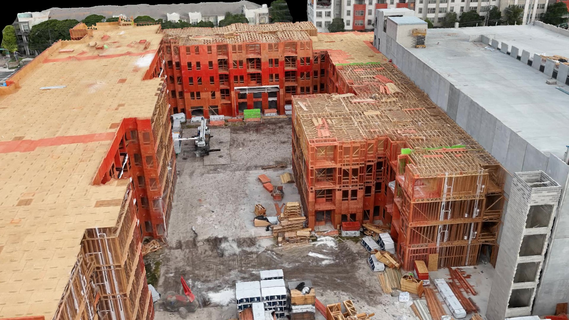
Fully Interactive 3D Models — Track Progress, Coordinate Teams, and View Your Site From Anywhere
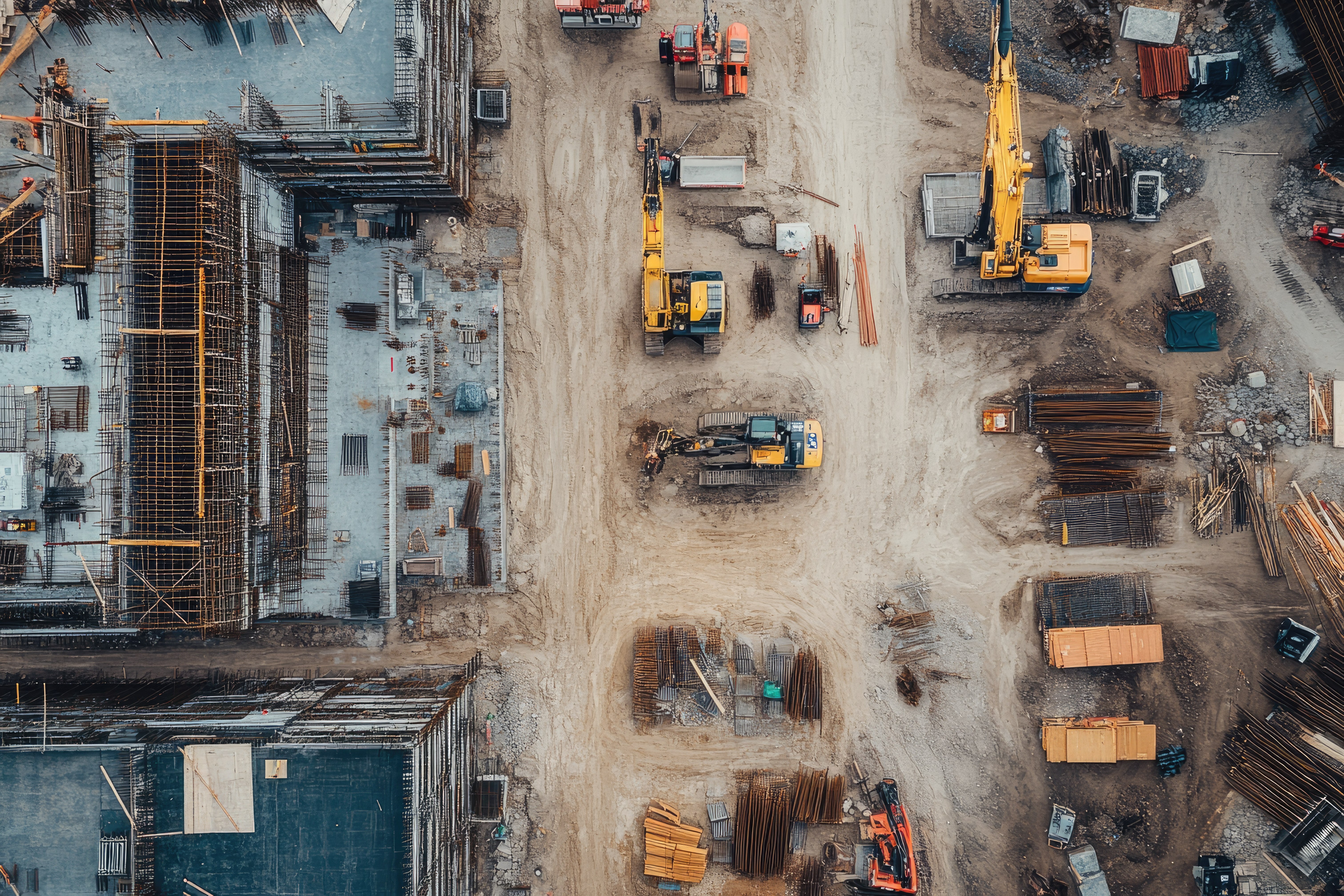
High-Resolution Site Models for Construction
At FlightScan, we provide high-resolution 3D models and comprehensive site imagery for construction projects — giving project managers, contractors, and field teams clear, up-to-date views of jobsite conditions. Captured by drone, our digital twins reveal the full scope of your project, enabling remote viewing, progress tracking, and more effective coordination.
Models are typically delivered within 24 hours to keep your team informed and your project moving. No apps or downloads required — just a simple link that works on any device.
Access points, staging areas, and other key features can be added directly to the model, transforming it into a powerful tool for field coordination. From single-lot builds to large-scale developments, our speed and precision help keep Austin-area jobsites on track.
Explore The Full Benefits Of 3D Site Models
Why 3D Models Are A Game-Changer for Construction Projects
Construction sites are complex, expensive, and fast-moving ecosystems — with dozens of companies, hundreds of workers, and millions of dollars on the line. Keeping everyone coordinated, informed, and up to date is a constant challenge. That’s where high-resolution 3D modeling offers a smarter solution.
Remote Viewing: See Your Site, Anytime, Anywhere
With detailed 3D models delivered regularly, project managers, owners, and stakeholders no longer need to be physically present to get an accurate picture of progress. This remote access saves time and travel costs, and keeps all parties aligned. Whether on a desktop or mobile device, users can:
- Orbit, zoom, and pan through a photorealistic site overview
- Inspect key details from survey stakes to staging areas
- Share insights easily with remote teams, subcontractors, or city officials
A Reliable Record of Work Performed
3D models serve as a visual record of site conditions, capturing exactly what was built, where, and when. Rather than relying on photos or text reports, everyone benefits from a shared, detailed visual. This timestamped evidence can be invaluable for:
- Checking site preparation and form builds before concrete pours
- Documenting completed work for inspections or audits
- Resolving disputes by providing an impartial snapshot of progress
General Overview: Planning and Coordination Made Easier
Beyond tracking progress, 3D models help teams plan smarter. Labeled models make it easy to communicate site access, parking, and drop-off zones — reducing confusion and helping crews get where they need to go without delay. Instantly get everyone on the same page and give your team the clarity to coordinate more effectively.
Because our models are hosted online, you can easily share a simple link with anyone who needs to see the site — no special software or training required. From project owners to subcontractors and field crews, everyone gains instant access to the same up-to-date information. This improves transparency, speeds up decision-making, and helps even day-to-day site workers understand layout, staging, and access zones before setting foot onsite.
- Clarify site logistics like access points, equipment staging, and crane zones
- Identify potential conflicts or hazards before they cause delays
- Provide new subcontractors or workers with a virtual site orientation
The Bottom Line
In construction, every decision, delay, and detail matters. A high-quality 3D model isn’t just a visual — it’s a powerful tool for keeping your project on track. By capturing your site with precision and turning it into an interactive reference, you enable your team to:
- Stay connected and make informed decisions from anywhere
- Track progress with confidence using time-stamped visual records
- Streamline coordination between trades, crews, and stakeholders
In today’s fast-moving industry, clear site visibility gives you a real advantage. FlightScan delivers it — quickly, seamlessly, and built around your needs.
How It Works
Site Capture
After scheduling, we manage all logistics, including site confirmation and airspace checks. On the day of your flight, our team captures high-resolution imagery from various angles and elevations to build an accurate 3D model of your site, all without disrupting your operations.
Post Flight Processing
Captured imagery is transformed using advanced photogrammetry into a detailed 3D model and high-resolution visuals. Need specific areas labeled—such as site access or staging areas? Send us the details, and we’ll add the labels directly to your model. We can also update or adjust them as your project evolves.
View & Share Instantly
Within 24–48 hours, you’ll receive a link to your personalized FlightScan page. Here, you can explore your 3D model, detailed orthomosaic map, and immersive 360° site video. Everything is hosted online, accessible from any device with just a click—no apps, logins, or software required.
What’s Included in Your FlightScan?
High Quality 3D Model
A clear, accurate view of your site — helpful for planning, coordination, and showing progress to clients or crews. Access instantly from any device.
Orthomosaic Map
A detailed, high-resolution top-down image of your site, stitched together from hundreds of drone photos.
360° Site Video
An immersive 4K video of your site. When captured over multiple flights, these are stitched into a time-lapse showing site progression.

Why Choose FlightScan?
- View The Entire Site From Anywhere: No need to be onsite, get a full, detailed view from wherever you are.
- Save Time: Keep your team aligned and projects moving with high-resolution updates on demand.
- Boost Communication: Get everyone on the same page with easy-to-share visuals and real-time site context.
- Instant Access: Just click to view — no apps, installs, or logins required. Everything is hosted online.
- Flexible Scheduling: Book a single flight, milestone check-ins, or recurring coverage.
- Fast Delivery: Products ready in 24–48 hours for sharing, reviewing, and reporting.
- FAA Licensed & Insured: Certified pilots operate under FAA Part 107, fully licensed and insured for commercial work.
Explore A Fully Interactive Sample Model
Phone or Tablet: Tap and drag to rotate, pinch to zoom in/out, use two fingers to pan.
Desktop: Click and drag to rotate, scroll to zoom, right-click and drag to pan.

.
Book Your Free Demo Flight
Try our services risk-free with no obligation — available for new clients and projects.
Get a brief 4K aerial video and 6–8 high-resolution photos of your site, delivered within 24 hours.
Perfect for viewing current site conditions and keeping your team updated.
Your message has been sent
Email: info@atxflightscan.com
Location: Based in Austin, TX — Serving Central Texas
